The Project
Over the past decade, solar farms have become a common feature of the British landscape with thousands in operation around the country.
Solar farms use photovoltaic (PV) panels to generate energy from daylight and distribute it through the existing electricity grid to homes and businesses in the local area and nationwide.
The site, within both the East Staffordshire and Staffordshire Moorlands districts, at New Buildings Farm is located away from the settlements of Stone and Draycott in the Moors. The maximum height of the entire development is expected to be no more than 3m from the ground and development will be positioned within existing fields so that hedges and trees will not need to be removed.
Solar farms make very little noise in operation and should not be audible outside of the development itself. At the end of its 40-year operational life, the equipment will be removed, and the entire site restored to its current use. This will be secured through a planning condition and is part of REPD’s legal obligation to the landowner.
Traffic
Once operational, solar farms generate almost no traffic. Visits for maintenance are required every few months. The construction process is rapid, lasting only a few months.
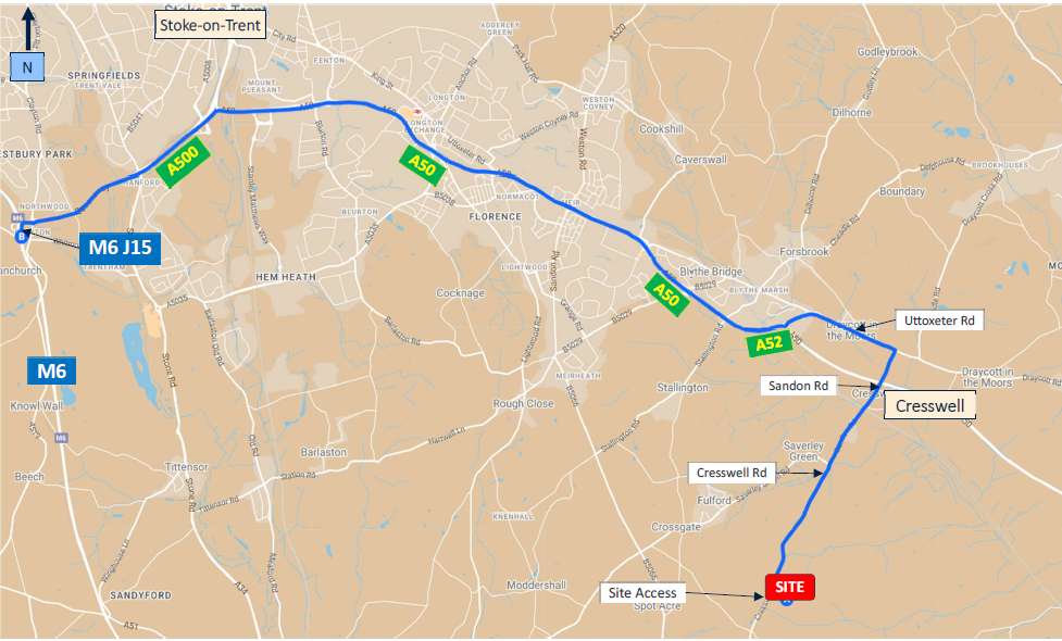
Access into the site by construction vehicles will be taken from Cresswell Road. Construction traffic will turn into the existing farm access which will be used to access the development fields. An internal access will also be created to serve the fields located within the development site area.
These access points will also be used for operational purposes. Construction noise will be kept to a minimum, with operations restricted to normal working hours.
Construction Access Route
Planning Application Documents
New Buildings Solar Farm Ltd have commissioned a comprehensive set of surveys to help determine both the site area, layout and design, so that any potential impacts can be minimised whilst also identifying opportunities to enhance the proposal. These are presented in a Planning Design and Access Statement that accompanies the application. In summary:
- Landscape and visual
impact assessment
This has helped determine the maximum height of the development, the position of equipment, and to minimise the effect of the development on the surrounding area.
- Glint and Glare and Noise Assessment
A Glint and Glare assessment has been undertaken which assesses the possible effects of glint and glare on the road and residential receptors in the area surrounding the proposed development.
A Noise Assessment has been undertaken to assess the potential noise impact associated with the proposed solar farm.
- Construction traffic assessment and management plan
Transport specialists have proposed that construction traffic accesses the site from the west, entering the site from Cresswell Road, to minimise the impact on nearby villages. The construction period expected to last no more than 25 weeks.
- Arboricultural survey
This has identified important trees within and around the site, including those at Bromley Wood. The findings of this survey have been used to ensure that all important Grade A and Grade B trees are retained, and Root Protection Areas (RPAs) maintained, where possible.
- Analysis of agricultural land grade
No agricultural land will be lost. The site is currently a mix of grassland and grazing. The solar farm is designed to allow sheep to graze under and around the panels during operation, providing a dual benefit of agriculture and energy generation. An agricultural land classification survey has confirmed the land to be largely lower grade 3b, i.e., not best and most versatile land.
- Heritage and archaeology assessment
These have considered listed buildings, scheduled monuments, and conservation areas in the area. The development has been positioned such that the nearest scheduled monument is 1.2km away from the site and any other scheduled heritage areas have been minimally impacted. A non-designated moat was identified close to the southern boundary and Bromley Wood. The parcel with the moat has been removed from the proposed development area and no groundworks will therefore take place within this area of land. A geophysical survey has also been undertaken to help assess the potential for archaeological features below the ground.
- Ecological appraisal
There are a number of locally designated wildlife sites within 2km of the site, including Bromley Wood Ancient Woodland immediately adjacent to the site to the south. Following a Badger Survey, a buffer zone has been incorporated around the identified badger sett. Additional eDNA testing of ponds on site also found no evidence of habitation by Great Crested Newts. Significant ecological enhancements are proposed, including creation of breeding bird habitats in the areas left free of development. Extensive grassland planting plus bird and bat boxes are expected to be included as habitat enhancements as well. We would welcome your suggestions on how we might improve these proposals.
- Flood risk assessment and surface water management survey
The site is located within Flood Zone 1 which is the lowest level of flooding. The proposed development will not increase flood risk elsewhere.